Zimbabwe: Geography and Environment
Elizabeth Szokol
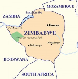
Zimbabwe is located in Southern Africa and is bordered by Mozambique, South Africa, and Botswana. Zimbabwe is a landlocked country. The Kalahari Desert is on the Southwest edge of the country. The country slopes towards the Zambezi River Valley. Near Mozambique and on the Eastern edge of Zimbabwe, many mountains can be found. Most of the rivers found in Zimbabwe drain into the Zambezi River. From the Zambezi River, the water flows to the Limpopo Basins and then into the Indian Ocean. In 1958, Lake Kariba, a manmade lake, was created on the Northwest border to prevent the flooding of the Zambezi River. (“Zimbabwe: Landforms and Climate”, World Geography). The country has a tropical climate, moderate temperatures, and low humidity. (“Zimbabwe: Country Overview”, World Geography) Despite this, Zimbabwe faces many issues.
The country of Zimbabwe is extremely far away from America and has different problems to deal with than America. There are four major issues that took place in Zimbabwe over the last number of years: deforestation, water contamination, overpopulation, and the use of pesticides. Deforestation is present throughout all of Zimbabwe. Since the very beginning of the state, deforestation is the process in which forests are destroyed in order to make room for more farming land. The reasoning behind the land becoming farmland is because the forests that were cut down were commonly rain forests and were lesser value to the popuation. Rain was plentiful in rain forests, which made the soil excellent for farming. Deforestation continued to spread rapidly throughout the country. In the farms that were created from deforestation and most of the other farms in Zimbabwe, the use of pesticides was very common. The pesticides that were used put some wildlife species in danger, such as birds. If the birds were to interact with the pesticides in some way, birds would then not have the ability to reproduce. Zimbabwe was a country packed with people, but when are there too many people? Zimbabwe reached the point when the country became overpopulated. Because of poor plumbing and an inability to adequately create a safe water supply, the people in this overpopulated country were forced to drink contaminated water. The water was contaminated due to improper sewage treatments. Fortunately, these issues are not present in America, today in the 21st century, but Zimbabwe suffered as they scrambled to resolve their problems. (“Zimbabwe: Environment”, World Geography).
Paragraph.
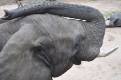
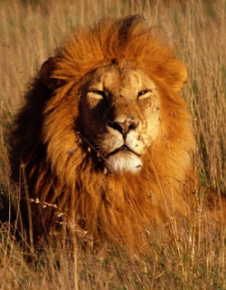
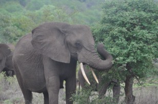
Zimbabwe is a unique country for several reasons. Its rare wildlife differentiates it from all other countries in Africa. Elephants, buffalos, lions, cheetahs, hyenas, zebras, girraffes, jackal, monkeys, nyalas, rhinoceroses, and antelopes are animals located in Zimbabwe. However, not all of these species are common. The samango monkey, king cheetah, and nyala are incredibly rare. Zimbabwe is one of the few places in the world where rhinoceroses can be found. Rhinoceroses are endangered because poaching is common among them. Poachers specifically target Rhinoceroses because their horns can be sold for a significant amount of money on the black market. In the 1980’s there were about 3,000 Rhinoceros in Zimbabwe. Currently there are only about 400 rhinoceros left in the wild in Zimbabwe. Sadly, rhinoceroses were not the only species who were in danger. Elephants were suffering from the same problem which resulted in National laws for elephant protection. This law was created in the 1920’s in order to preserve Zimbabwe as a home to animals such as these. (“Zimbabwe: Environment”, World Geography).
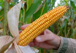
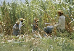
At first glance, a person might never think that Zimbabwe had an agricultural business or even any advanced energy sources. In reality, Zimbabwe has several different energy sources and for a long time their agricultural business was soaring. The most common crops that were grown on farms were corn, tobacco, wheat, oilseed, coffee, peanuts, sugarcane, sorghum, soybeans, rice, pyrethum, sunflower seed, tea, potatoes, and corn. The best farming land was found in the Northeast because it had the ideal amount of rain. Premium coffee beans were found in Eastern Zimbabwe, in the highlands. Sugarcane was the major crop in the South and corn was one of the most popular crops grown in the Northeast. Sugarcane was not only used for sugar but it was also used for fuel as ethanol. Not only were corn and sugarcane popular, but beef cattle became a large part of the agricultural base in Zimbabwe. Unfortunately the momentum did not last. This was not a manmade problem but one from mother nature. The continual drought stopped farm production. Not only did farms shut down, but so did factories. Factories relied on coal for energy. However, coal production dropped in 2003 from 3.7 million tons to 2.9 million tons. The decline of coal production resulted in the companies shutting down. Zimbabwe needed a new energy source so they built hydroelectric dams. The dam between the Zambezi River and Lake Kariba supplied the country with most of its hydroelectric energy. Zimbabwe was at its greatest height during this period, but it slowly began to decline. (“Zimbabwe: Natural Resources and Agriculture”, World Geography).
“Zimbabwe: Country Overview”. World Geography. ABC Clio. 30 Apr. 2009. http://ntesx01-lic.nths.net:2105/countries/Display.aspx?countryid=218. This article was short but provided very useful information. I learned where Zimbabwe is located and what countries border it. Some rivers were mentioned and the weather was also mentioned.
"Zimbabwe: Environment." World Geography. ABC Clio. 30 Apr. 2009 http://www.worldgeography.abcclio.com/countries/display.aspx?regionid=1&countryid=218&pagetypeid=3. From reading this, I learned about the different animals and environmental issues that took place in Zimbabwe. This article went into much detail when explaining the problems that Zimbabwe had to deal with.
“Zimbabwe: Landforms and Climate”. World Geography. 30 Apr. 2009. ABC Clio. http://www.worldgeography.abc-clio.com/countries/ Display.aspx?regionid=1&countryid=218&pagetypeid=1. This provided me with great information. The article explained where different landforms were located such as mountains and rivers. I also learned about what the weather is like in Zimbabwe.
“Zimbabwe: Natural Resources and Agriculture”. World Geography. ABC Clio. 30 Apr. 2009. http://www.worldgeography.abc-clio.com/countries/ Display.aspx?regionid=1&countryid=218&pagetypeid=2. This article when very in depth regarding the locations of where certain crops were once grown in Zimbabwe. In addition, it provided me with some information about the energy sources that power the country of Zimbabwe.
Last updated by Elizabeth Szokol at 7:34 a.m. Friday May 22, 2009
